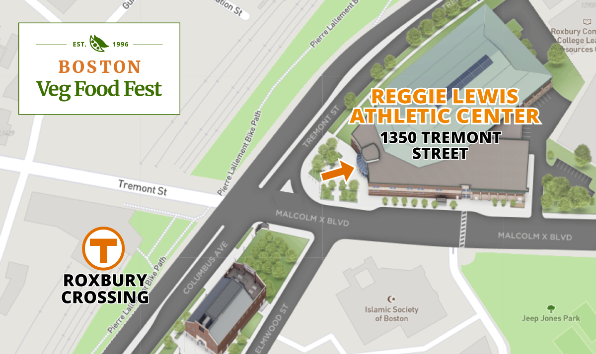
Boston Veg Food Fest Location
Reggie Lewis Athletic Center
1350 Tremont Street (at the corner of Malcolm X Boulevard)
Boston, MA 02120
Maps
- Parking Map
- Get Google Directions from your location (also see Driving Directions below).
- Move around the Campus Map to view buildings and parking lots.
Lodging
See Boston Area Accommodations and Travel Resources
Public Transportation
The best way to reach the Festival is by T (MBTA subway or bus). We are conveniently located across the street from the Roxbury Crossing T station on the Orange Line.
MBTA subway schedules and map
Use the MBTA’s Trip Planner
Subway
 The Orange Line T Roxbury Crossing station is diagonally across the street from the Reggie Lewis Athletic Center. Map of T
 The Green Line “E” trolley (Huntington Avenue) Museum of Fine Arts stop is 3/4 mile from the Reggie Lewis Athletic Center. When you disembark, with your back to the Museum, walk away from the Museum onto Ruggles Street, passing Wentworth Institute on your right. Continue on Ruggles St. to Tremont Street and turn right at the Boston Police Headquarters. Walk one block on Tremont Street and turn left at Malcolm X Boulevard. RLTAC is on the corner of Tremont and Malcolm X Boulevard.
Bus
Take bus # 15, 22, 23, 28, or 66 and get off either at the Roxbury Crossing T Station or at the corner of Tremont/Columbus and Malcolm X Boulevard.
Bikes
There is a BLUEbikes public ride share station at the Roxbury Crossing T station, and at the Whittier St. Health Center next to Reggie Lewis on Tremont St. MAP (Type in Roxbury Crossing T Stop)
Commuter Rail
At Ruggles Station on the Purple Line (MAP), change to the Orange Line T heading outbound towards Forest Hills. Go one stop and get off at Roxbury Crossing. The Reggie Lewis Athletic Center is diagonally across the street. OR, you can walk by exiting Ruggles Station onto Tremont Street. Turn right and walk west on Tremont St. for 4/10 mile to the intersection at Malcolm X Boulevard. The Reggie Lewis Center is on your left.
Amtrak
Disembark Amtrak at Back Bay Station (five minutes before the final stop at South Station). Change to the Orange Line T heading outbound towards Forest Hills. Go three stops and get off at Roxbury Crossing. The Reggie Lewis Athletic Center is diagonally across the street.
Parking
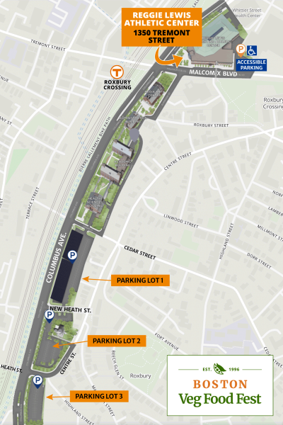 There is free parking in three lots near the Reggie Lewis Athletic Center (RLAC). There is also free street parking along Malcolm X Boulevard, but watch for signage for bus stops, etc.
See Parking Map and Campus Map.
Lot 1: Located along Columbus Ave. (Tremont St. becomes Columbus Ave. when it passes RLAC), enter from Cedar Street. It is a 2/10 mile walk to RLAC. A canopy of solar panels has been installed above the parking lot. Has 320 parking spaces.
Lot 2: Located along Columbus Ave., enter from New Heath St.
Lot 3: Located along Columbus Ave., enter from Centre St. It is a 1/2 mile walk to Reggie Lewis.
Note: There is additional parking behind Madison Park School that is not shown on our parking maps. Enter the driveway on Tremont St. to the left of Whittier St. Health Center (immediately behind the Reggie Lewis Center). Go straight down the slight decline to the STOP sign. Go straight through, and parking is allowed on the weekends in the area near the school, despite the signs prohibiting it. Do NOT turn left at the STOP sign into the other parking area. That is permit only.
Accessibility
The entrance to the Reggie Lewis Athletic Center is wheelchair accessible (no steps). There is a staffed security desk immediately ahead as you enter.
There is an elevator in the main entrance lobby to the right as you enter.
The Exhibitor Room is on Floor 1 (the ground floor). Bear right from the main entrance, and go down the hallway.
On Floor 2, accessible by elevator, are the Speaker Room, Kids’ Activity Room, and table seating for eating on the Mezzanine overlooking the entry lobby.
There are accessible restrooms on Floors 1 and 2. On Floor 1 (the ground floor), there are large restrooms to the left (as you enter) of the main entrance door, and smaller restrooms off the hallway near the entrance to the exhibitor room. On Floor 2, the rest rooms are just to the right as you exit the elevator.
The BVS website and the festival website are ADA accessible and mobile-friendly.
Driving Directions
Get Google Directions from your location
From North of Boston:
Take Interstate 93 (Route 1) South to Southeast Expressway (I-93 / Rt 1 / Rt 3) and go off at Exit 15 (Mass Ave / Roxbury).
Carefully follow the signs for Mass Ave / Roxbury. Go straight across Mass Ave at the light, and continue on to Melnea Cass Blvd. Follow Melnea Cass Blvd to the end (just under 1 mile). Turn left onto Tremont Street and travel about 4/10 mile. The Reggie Lewis Athletic Center is on your left.
From South of Boston:
Take Interstate 93 (or Route 1 or Rt 3) North to Southeast Expressway. Go off at Exit 15B (Mass Ave / Roxbury exit).
Carefully follow the signs for Mass Ave / Roxbury. Go straight across Mass Ave at the light, and continue on to Melnea Cass Blvd. Follow Melnea Cass Blvd to the end (just under 1 mile). Turn left onto Tremont Street and travel about 4/10 mile. The Reggie Lewis Athletic Center is on your left.
From West of Boston:
Take Mass Pike (I-90) East to Exit 133 (Prudential Ctr / Copley Sq, formerly called Exit 22). Bear right for Copley Square. Take the first right at the light onto Dartmouth St. At the third light, turn right onto Tremont St. Go 1.3 miles to the light at Malcolm X Boulevard. The Reggie Lewis Athletic Center will be on your left.
From Northwest MA:
Take Route 2 East to Exit 40A (Route 495 South). Travel Route 495 South and exit onto Mass Pike (Rt. I-90) East. Follow directions above “From the West.” Note: If you follow Route 2 all the way into Boston, you will encounter rotaries, traffic lights, and local roads. It is better to get on the Mass Pike as indicated.